CLI LAND CAPABILITY OF THE REGINA MAP AREA,72 I
The Canada Land Inventory provides one of the most comprehensive digital map source for resource planning and management in Canada. The area covered by the CLI is indicated in the index map. For each of the map sheets areas land capability is mapped at 1:250'000 scale and usually at a 1:50'000 scale. This is an example for Mapsheet 72I, Regina. The index map on the right shows the areas mapped for land capability under the CLI. The left image shows an example of a number of overlays displayed on Google Earth.
 |
 |
Each of the 1.250'000 scale maps has an extensive description of the landscape ecosystem and capability perspectives. Below is an example for the Regina map area.
Table of Contents
INTRODUCTION
CLIMATE
RECREATION CAPABILITY
MAIN SOIL CHARACTERISTICS
AGRICULTURE
ECOLOGY
WETLAND CLASSIFICTION
LAND CLASSIFICATION FOR UNGULATES
The area covered by the Regina map sheet comprises about 6,100 square miles in south-central Saskatchewan. It lies on the western edge of the Saskatchewan Plain in the Interior Plains physiographic region. Relief differences are minor. The highest elevations are about 1600 feet above sea level at Last Mountain Lake and 2800 feet in the Cactus Hills of the Missouri Coteau. The area is part of the grassland zone, but trembling aspen is common in the northeast and in valleys.
The main subdivisions in the Saskatchewan Plain division of the Interior Plains Region are the Regina Plain in the south, part of the Moose Mountain upland in the east-central part, and the Qu'Appelle Plain in the northern halt of the area. The Qu'Appelle Plain has elevations from 1600 feet above sea level at Last Mountain Lake to 2000 feet above sea level at its borders. The plain is gently undulating to rolling. It developed mainly on glacial or glaciolacustrine deposits and contains a network of meltwater channels. The streams that flow along these channels empty into the au'Appelle River, which occupies a main meltwater channel. The spillways that are cut 100 to 400 feet into the plain are blocked by dams, by moraines, or as in the Qu'Appelle River valley, by alluvial fans. The Regina Plain, which occupies most of the southern part, is predominantly a smooth lacustrine plain, between 1800 and 2100 feet above sea level. The Moose Mountain upland in the east-central part is undulating to strongly rolling. It developed on glacial till and rises 200 to 300 feet above the surrounding plains.
In the southwest are parts of the Missouri Coteau and the Old Wives Lake section of the Alberta Plateau. The Coteau, the eastern edge of the Alberta Plateau, presents a dissected, east-facing, steep slope to the Saskatchewan Plain and rises more than 700 feet above it. Hummocky ground moraine provides local relief of up to 50 feet. This part of the Old Wives Lake plain is undulating and has elevations from 2200 to 2400 feet. It developed on till deposits; local bedrock exposures of the Upper Cretaceous Period occur.
Although mixed grass prairie covers most of the area, small stands of trembling aspen occur in the northeastern part. In the Qu'Appelle River valley, bur oak, American elm, green ash, Manitoba maple, and cottonwood are found. The changes in climate and vegetation correlate with changes in soil zones. Brown, Dark Brown, and Black soils occur from southwest to northeast.

The area has a cold continental climate. The winters are long and cold, and the summers are short and fairly warm. The total annual precipitation is low. At Regina, the mean temperatures for January and July are 1.60 F and 66.70 F. respectively; the absolute minimum and maximum temperatures are -540 F and 1100F. The total precipitation of 15.5 inches includes 43 inches of snowfall, 4.3 inches water equivalent. Precipitation is heaviest from May to September. Because of the small increase in precipitation and the slight decrease in summer temperatures from southwest to northeast, the area is divided into the semiarid southwest and a subhumid northeast. The average frost-free period of 110 to 90 days decreases from southwest to northeast.
Most of the area is rated as Class 6 since the mainly treeless plains have a low physical capability for recreation. The northeast face of the Dirt Hills on the Missouri Coteau is rated as Class 4. This wooded section has potential for viewing and picnic sites and riding and hiking trails. The slopes are steep and long enough for skiing, but they may lack adequate snow cover. Elsewhere, higher capability lands are confined to the spillways and their associated waters.
The Qu'Appelle River valley has walls up to 400 feet high and is the most scenic of the glacial spillways. The valley is well suited for riding and walking and the tributary coulees, which are generally wooded, provide attractive environments for camping and picnic grounds. There are several excellent viewpoints and skiing may be possible on some of the north-facing slopes. Eastward from Lumsden, the meadows and wooded banks of the winding river create an attractive canoe route with few portages. Only part of Pasqua Lake, the poorest of the four Fishing Lakes of the Qu'Appelle River valley, is in the area. The western end of the lake is shallow and weedy and suited mainly to the viewing and hunting of the abundant wetland wildlife. The eastern end is better suited to boating, fishing, and camping. The foreshore, as in the other spillway lakes, is narrow and contained by the steep valley walls; access is often difficult.
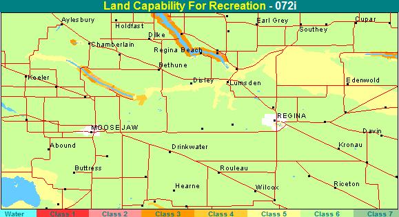
The construction of a dam has improved Buffalo Pound Lake. Spillway walls, especially on the northeast shore, come down to the water, and erosion and slumping are common. Coarse materials dominate the narrow beaches and the steep banks make access difficult. As in many other lakes in southern Saskatchewan, the presence of algae may affect swimming enjoyment.
Last Mountain Lake, the largest of the spillway lakes, is 50 miles long and one mile wide. Over half of the lake is in the area. Last Mountain Lake has a maximum depth of 100 feet and is good for boating and angling. The lake water is of fairly good quality. Some sand and gravel beaches have been developed as cottage subdivisions. The lack of adequate tree cover on the spillway walls detracts from the quality of the backshore areas. The marshy southern end of the lake supports many shorebirds.
No other lakes in this area have high recreation capability. Old Wives Lake is shallow, muddy, saline, and of changing size. It has no recreation potential other than its significance as a nesting ground for pelicans. Wascana Lake, Condie Reservoir, and the other wetlands have similar wildlife value.
Description by Dr. J. H. Richards, Department of Geography,
University of Saskatchewan, Saskatoon, Saskatchewan. Capability classification
by D. McKay, J. H. Richards, and others.
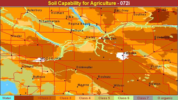
The soils in the area are developed on lacustrine, alluvial lacustrine, alluvial glaciofluvial, and glacial till parent materials in the Brown, Dark Brown, and Black soil zonar. Dark Brown Chernozemic soils occupy approximately 75 percent of the area and have a capability rating ranging from Cross 2 to Class 5. There developed on fine-textured lacustrine parent materials (Regina and Tuxford soil associations) are the most productive of this group and are rated ar Class 2 soils, their only limitation being that of a moderate climatic moisture deficiency. The moderately fine and medium textured soils (Amulet, Weyburn, Elrtow, and Bradwell soil associations) are rated as Class 3 due to a moderately severs deficiency in moisture-holding capacity but may be reduced further due to additional limitations of the landscape. Moderately coarse and coarse textured deposits (Asquith and Biggar soil associations) rate are Class 4 and 5 depending on the severity of the adverse soil characteristics.
Thin Black Chernozemic soils ore confined to the northeast part of the map sheet, occupying about 15 percent of the map area. Soils developed on moderately fine and fine textured lacustrine parent materials (Bolcarres and Edgeley soil associations) are rated os Class 1 whereas soils developed on mediumtextured deposits (Oxbow soil association) on similar landscapes are rated or Class 2 due to a moderate deficiency in moisture-holding capacity.
The Brown soils occupy less than 2 percent of the area and are confined to the extreme southwest corner of the map sheet surrounding Old Wives Lake. The line and moderately fine textured soils (Sceptre and Ardill soil associations) are generally rated as Class 3 soils whereas the moderately coarse and coarse deposits (Hatton and Chaplin soil associations) are Class 4 or 5 according to their degree of moisture-holding deficiency.
Gleysolic soils are the most widely distributed soils in the map sheet area, but they generally occupy less than 25 percent of any particular area. They occur as intermittent or permanently wet sloughs or depressions and are generally rated as Class 5 or 6 depending on whether or not improvement practices are considered feasible.
Azonal soils characteristic of the alluvium and hillwash complexer occupy about 10 percent of the area, occurring in association with the main drainage channels or their adjacentfloodplains. The variable-textured alluvial deposits (Alluvium, Caron, Wascana, and Rouleau soil associations) have varying limitations due to wetness, structure, or salinity. Hillwash soils are reduced to Class 5 or 6 due to adverse topography and erosion.
Settlement of the area began with the coming of the transcontinental railway in 1882, which saw the earlier 'Pile of Bones' crossing become the site of the present city of Regina. It was severely retarded, and accompanied by major abandonment of settlement, throughout the eighties and nineties as a result of recurring year of severe drought. In 1886, colonization settlements were established in the east and southeast of the area, and a settlement along the south end of Last Mountain Lake was started under the auspices of the Qu'Apelle Land Company. An influx of Ontario settlers into the Regina-Moose Jaw area occurred in 1889, and some settlement by United States immigrants followed the opening of the Soo Line. The main settlement, however, did not occur until after 1900, reaching its peak in the period up to 1906. Settlement of the southwestern, northwestern, and northeastern parts of the area occurred somewhat later and fill-in settlement of these parts of the area continued into the 1920's.
The area includes a portion of the Brown soil zone in the southwest and straddles the Dark Brown, fringing on the Black soil zone in the northeast. Its agriculture reflects this zonal transition or well as its brood diversity of soil and land types. It is dominated by the large area of level heavy clay soils commonly known as the Regina Plains in which arability is over 90 percent, giving superb adaptation to specialized grain production. Broken topography in the northwest end wooded cover in the northeast reduce arability to about 70 percent, contributing to a more generol incidence of mixed farming. In the southwestern part, in turn, additional droughtiness, coupled with adverse topography and coarse-textured soils, reduces arability to below 50 percent of occupied area, resulting in a broad admixture of specialized grain farming with grain-cattle combination and semiranching types of operations.
Wheat comprises from 70 to over 80 percent of the annual crop acreage of municipalities of the Regina Plains and 60 to 70 percent of the other parts. Coarse grains make up 10 to 15 percent of annual crop in the former area, and are grown more commonly for cash sale than for feeding on the farm. In the other areas coarse grain acreages range from 15 to 20 percent of annual crop acreage and are more commonly used for feed. Flax is a significant secondary crop, particularly on the Regina Plains, and durum wheat and molting barley are also quite widely utilized for cropping diversification. Seeded forage acreage is generally low, ranging from 5 to 7 percent of cropland acreages for outlaying parts and about 3 percent for the Regina Plains.
Livertock emphasis in the area includes a limited concentration of fluid milk operations in the Regina and Moose Jaw milk sheds; a more general incidence of mixed livestock operations in the mixed farming area toward the east and northeast; rcattered grain-cattle combination farming in association with the larger areas of uncultivated land in the rougher topography towards the west and northwest and the poorer soils along the south; and more common grain-cattle combination and smell-scale ranch operations in the southwest. Cattle easily rank as the dominant form of livestock; hog and poultry numbers are low throughout the area.
The two-year cropping system is the dominant system in the Plains port or well as throughout a large port of the remainder of the area. Summerfallow generally exceeds 40 percent of the cropland acreage, ranging to over 45 percent for individual municipalities of the Regina Plains. Flexible use of second-cropping is a common practice and regular use of the three-year cropping system is more common in the mixed farming area towards the northeast.
Farm sizes for the area are somewhat larger than for other parts of the Dark Brown zone but are widely dispersed and still include a substantial part of relatively small units. Size adjustment has been more moderate than in many other parts of the Province, most municipalities reporting about two-thirds of their former highs of form numbers. The droughty areas along the south and southwest have undergone more severe adjustment, with present farm numbers ranging below 60 and down to 50 percent of former peak farm numbers.
Capability classification by J.A. Shields and J.S. Clayton based on soil information contained in Saskatchewan Soil Survey Reports.
*Agriculture - prepared by H. Van Vliet, Head, Department of Agricultural Economics, University of Saskatchewan.
A mixed prairie vegetation type occurs in the semiarid southwestern and western parts of the area, where western porcupine grass (Stipa spartea var. curtiseta) and northern wheat grass (Agropyron dasystachyum) dominate. On the drier sites spear grass (Stipa comata) and western wheat grass (Agropyron smithii) are most common, whereas on clay-textured soils, June grass (Koeleria cristata) and northern wheat grass are prevalent. Many other forbs and shrubs occur, including pasture sage (Artemisia frigida), silver sagebrush (Artemisia canal, western snowberry (Symphoricarpos occidenralis), and silverberry or wolf willow (Elaeagnuscommutata). Trembling aspen (Populus tremuloides) and willow (Salix spp.) are restricted to moist, sheltered de-pressions.
The parkland or aspen grove vegetation type is found in the more humid northeastern part of the area. Trembling aspen is usually found in pure stands, except on poorly drained sites, where it is associated with balsam poplar (Populus balsamifera). Rose (Rosa spp.), choke cherry (Prunus virginiana), saskatoon (Amelanchier alnifolia), and occasional pin cherry (Prunus pensylvanica) form the shrub understory, with red-osier dogwood (Cornus stolonifera) in the moister locations.
The ungulates that are found in the area are pronghorn antelope (Antilocapra americana), white-tailed deer (Odocoileus virginianus), and mule deer (0. hemionus). Pronghornantelope and mule deer are restricted for the most part to the extreme southwest in the Coteau and Old Wives Lake areas. White-tailed deer occur throughout the area, but are concentrated in the Moose Mountain uplandand north of the Qu'Appelle River valley.
Marsh and meadow plant species are similar for the mixed prairie and parkland regions, except that leafy three square bulrush (Scirpus paludosus) is more common on the mixed prairie and round stem bulrush (S. spp.) is found more often in the parkland. Commonly occurring plants in shallow fresh sloughs are: rushes (Neocharis palustris and Juncus belticus), awned and beaked sedge (Carer spp.), grasses (Celamegrostis spp., Glycerie spp., Beckmennie spp.), water plantain (allisma spp.);-and arrowhead (Sagittaria cuneata). The more permanent fresh sloughs are usually fringed with roundstem bulrush or whitetop (Scolochloa festucacea).
Three square bulrush is usually found on the more permanent saline locations. Other plants commonly occurring in saline sloughs are:wild barley (nordeum jubetum), alkali grass (Distichlis stricta), samphire (Selicornia rubre), sea blight (Suaeda erecta), gum weed (Grindelia squarrosa), and greasewood (Sarcobatus vermicultetus).
A wide variety of submergent aquatics occurs throughout the sheet. Most common are: sage pondweed (Potemogeton pectinatus), clasping leaf pondweed (P. richerdsonii), widgeon-grass (Ruppia spp.), whitewater crowfoot (Renunculus subrigidus), milfoil (Myriophyllum eralbescens), coontail (Ceratophyllum demersum), and bladderwort (Utriculsria vulgaris). Two species of duckweed (Lemna spp.) are common.
The area is more important as a breeding ground for surface feeding ducks than for divers. Common nesting dabblers are: mallard, pintail, blue-winged teal, shoveler, gadwall, and widgeon. Diving species which usually nest on the larger marshes are: canvasback, redhead, ruddy, and lesser scaup. An introduced population of Canada gease nests in Wascana Park within the Regina city limits and on Boggy Creek north of the city. The American coot is abundant throughout the area.
Most of the area is used for the production of cereal grains. Cattle raising is important in some locations especially in the Missouri Coteau, which, because of topography or soil texture, are unsuitable for cuItivation.
The best habitat for waterfowl production for this area is found in the Wood Mountain Upland in the northeast part. Most of this unit is rated Class 1 to 3. The main limitation is too gently undulating topography, but aridity is important on the Dark Brown soils. The places of highest production potential are found in undulating to rolling moranic deposits, which have a high density of bodies of water of different types. Unfortunately, many of the small bodies of water have been filled or drained for agricultural purposes. Egg Lake, which was once an excellent production place and imporTant migration stop, is now dry and farmed.
Ratings on the Assiniboine River Plain vary from Class 2 to 5. North of the Qu'Appelle River (moraine), the most important limitations are gentle topography and aridity, but poor water holding capacity is important on outwash plains. South of the Qu'Appelle River (lacustrine), production is limited chiefly by the extreme flatness of the Regina Plains and resulting absence of bodies of water. The part of the Last Mountain Lake in this area is limited by poor edge and depth, but is important as a migration stop. The same is true of Buffalo Pound Lake, except for the extreme northeast end, which has excellent production potential.

The Missouri Coteau is highly productive in consecutive wet years, but has Been rated down because of its susceptibility to drought. Steep topography, which limits edge development, is another important limitation. Bodies of water on outwash plains in this locality are usually limited by salinity. Old Wives Lake has poor edge development and is limited by salinity. It is important, however, as a migration area, although it is subject to botulism outbreaks. Frederick Lake is too saline for waterfowl use, at least at its present level.
The main river and creek systems (Qu'Appalle and Souris rivers, Moose Jaw and Wascana creeks), have good production potential. All are sluggish, fertile systems and are limited chiefly by their uniformity of habitat and distance from other water areas.
Capability classification by R. E. G. Murray end C. A. Matthews, Canadian Wildlife Service.
LAND CLASSIFICATION FOR UNGULATES
The lacustrine and morainic lands south of the Qu'Appelle River, excluding the Moose Mountain upland to the east, comprise about 60 percent of the area and have a low capability for ungulates. These lands were rated Classes 5 and 6 with topography the main limiting factor. Where the topography is rougher, aridity is the dominant limiting factor.
North of the Qu'Appelle River valley, the glacial till and glaciofluvial plains, which together comprise about 30 percent of the area, were rated Class 2 to Class 5 for deer, with Class 3 the most common rating. East of Last Mountain Lake extensive lands consisting of Oxbow soils were rated Class 2. The Moose Mountain upland, which occupies the rest of the area, was rated mainly Class 3 for deer, with isolated units of Class 2 and Class 4. The upland, a morainic till plain, has a landform limitation forwhite-tailed deer.
The Qu'Appelle River valley contains critical deer wintering habitat. Southfacing slopes were generally rated as Class 3 deer winter range with an exposure limitation. The valley bottom was rated as Class 3 winter range with inundation and landform limitations. North-facing slopes were rated Class 2 winter range for deer with a landform limitation. Small areas of wintering habitat were also mapped along Buffalo Pound Lake and Last Mountain Lake.
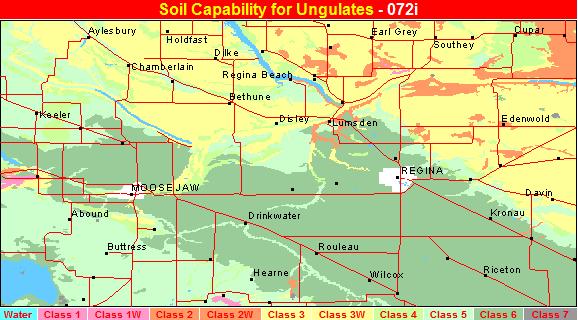
Extensive agriculture and the limited wildlife habitat restrict ungulate-based outdoor recreation in the area. Because of the high human population and good accessibility in the area, the ungulate harvest is at or near its maximum potential.
Capability classification by T. W. Rock and K. R. Scheelhaase, Fisheries and Wildlife Branch, Saskatchewan Department of Natural Resources.